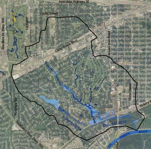
Dunaway worked with the City of Fort Worth to update previous studies and outdated floodplain delineations for Ridglea and Luther Creeks and tributaries by conducting an open channel study. Our civil engineering team performed detailed hydrologic and hydraulic analyses of the watershed to better define the 100-year floodplain limits and elevations and to develop mitigation alternatives for alleviating flooding in the Westridge Avenue/Vickery Boulevard area.
Data collection and visual observations revealed erosive conditions, channel stability issues, failed channel protection, sediment transport, and blocked obstructions. Twenty-three areas of concern were identified along the streams. Detailed models were developed to define the 2-, 5-, 10-, 25-, 50-, 100-, and 500-year frequency flood events, as well as estimated 100-year frequency flood events for future watershed conditions. Ten structures, six of which were homes, were identified within the one-percent annual chance floodplain limits due to the over-topping of four roadways. Additionally, Dunaway provided recommendations for improvements to four undersized culverts to minimize flooding.
-
Location:Fort Worth, Texas
-
Client:City of Fort Worth
-
Services:Civil Engineering