Shaping Cities: How GIS Pieces Together Places, People, and Data
 In our Shaping Cities series, we highlight the different phases of city development – offering insights into how we provide innovative solutions and strategic guidance to municipalities of all sizes.
Running a city is like solving a massive jigsaw puzzle – roads, pipes, buildings, parks, and people all interconnect. GIS is the puzzle master that helps bring clarity to complexity, fitting those pieces together, so decisions are based on the full picture, not just one corner.
Dunaway Difference
Dunaway delivers comprehensive GIS solutions (Geographic Information Systems) that empower cities, counties, and municipalities to manage assets, plan growth, and improve operational efficiency. Among the GIS services we provide to municipalities are enterprise GIS consulting, CAD-to-GIS conversions, mobile field data collection, and the development of interactive web maps and dashboards. These tools provide a single source of truth for infrastructure, utilities, and land-use data – helping local governments make informed decisions, streamline maintenance, and enhance transparency for the public.
Dunaway is proud to be an Esri Partner, fostering a strong and collaborative relationship with the industry leader in geospatial technology. By leveraging ArcGIS Online, we create dynamic, cutting-edge solutions that help our clients visualize, analyze, and succeed. We routinely lean on ESRI technical solutions and our account representatives for assistance when needed.
From supporting comprehensive planning in New Fairview to enabling economic development analysis in Duncanville and asset management for Coryell County, Dunaway tailors GIS strategies to meet the unique needs of each community. By digitizing critical data and implementing scalable systems, we help municipalities put the puzzle pieces together to reduce risk, optimize resources, and prepare for future growth.
Duncanville GIS Services – Duncanville, Texas
Improved access to infrastructure data and redevelopment planning.
Located in southwestern Dallas County, Texas, about 12 miles southwest of Downtown Dallas, the City of Duncanville is part of the “Best Southwest” partnership of cities, a subregion known for its strong community focus, proximity to major transportation corridors, and growing economic base.
GIS has become a powerful driver of Duncanville’s economic development strategy, enhancing transparency, planning, and data-driven decision-making. Following more than two decades of steady population growth – an increase of 7.7% between 2000 and 2023 – the city is now entering a new phase of strategic redevelopment, with GIS serving as a critical foundation for informed growth and investment.
To support these efforts, Dunaway mapped as-builts for the City of Duncanville, creating a Digital Plan Room to centralize construction records and improve access to infrastructure data. Using ArcGIS Pro, Dunaway drew project boundaries, attributed key details such as year built and project type, and hyperlinked plan documents directly to the city’s file server. Any associated easements were also mapped and categorized by type (e.g., water, drainage), facilitating a comprehensive and searchable record.
Beyond asset management, Dunaway has partnered with the city to leverage GIS for economic development – analyzing demographic trends, identifying top employers, and training staff to generate their own reports to support business planning and future growth strategies.
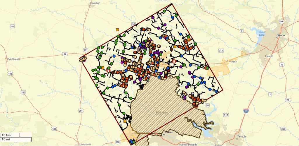
Coryell County GIS Services – Coryell County, Texas
Digitized hundreds of drainage assets and road networks to enable accurate future budgeting.
Located in central Texas, on the Edwards Plateau, Coryell County sits halfway between Dallas and Austin, covering an area of about 1,057 square miles. Dunaway’s GIS specialists are collaborating with Coryell County Road and Bridge staff to refine the county’s existing GIS data, including mapping and maintaining infrastructure such as roads, culverts, and cattle guards.
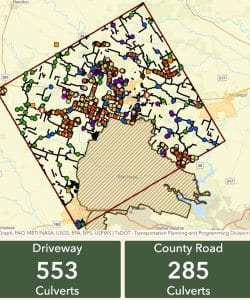
The department’s datasets include low-water crossings, field entrances, and driveways. However, the roadway layer lacks data specific to maintenance and repair. To resolve this, Dunaway is restructuring these datasets into individual layers, allowing staff to collect and edit data more efficiently.
The refined GIS data will significantly improve infrastructure management, enabling county staff to collect and update information in the field and use detailed maps to estimate repair costs. James Kiphen, Road and Bridge Maintenance Supervisor, explains: “We don’t have to wonder what’s on what road; we can simply resort to this app that Dunaway put together. Additionally, this tool is helping to save us roughly $100,000, providing us with knowledge without having to go around and dig anything up.”
This tool is helping to save us roughly $100,000, providing us with knowledge without having to dig anything up.
”With detailed asset maps and dashboards, the county can now estimate repair costs, allocate budgets, and present accurate data to decision-makers. “The experience has been wonderful,” Kiphen noted. “We are very pleased with the progress that it’s making and Dunaway’s attention to detail.” Dunaway is also training staff to use ArcGIS Online and the ESRI Field Maps mobile app, improving maintenance planning and record-keeping.
New Fairview GIS and Planning Services – New Fairview, Texas
Enabled public access to zoning and land-use maps.
Nestled on the western edge of Wise County, just 30 miles north of Fort Worth, the City of New Fairview was incorporated in 1973 to safeguard its rural charm from the looming suburban expansion. As the city grows into Denton County, the need for strategic planning and careful land management has become more critical than ever.
The growing city of New Fairview leveraged GIS for comprehensive planning, tracking parcels, zoning, land use, and making data accessible to both staff and the public. To facilitate this, Dunaway created a collection of interactive maps for the City of New Fairview to share with the City Council and other community members.
The web application provided a central location for finding information of interest, including zoning, road surface types, and existing and proposed subdivisions. GIS also enabled easy updates and data migration for future expansion and transparency. To provide the most up-to-date base data, Dunaway adds available live layer feeds from trusted sources, including Wise and Denton County Appraisal Districts, North Central Texas Council of Governments, Texas Railroad Commission, FEMA, and more.
Let’s Put the Puzzle Pieces Together
Ready to connect your community’s data pieces? Reach out to Dunaway’s GIS professional below to learn more about how our in-house database can help your community unlock data-driven decisions to deliver information quickly and efficiently.
About the Authors