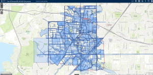
Dunaway developed a Digital Plan Room for the City of Duncanville by mapping as-built construction plans into a centralized GIS platform. Using PDF documents provided by the City, Dunaway created project site boundaries as polygons and added key attributes such as year built, project type, and hyperlinks to the original plans. The project was built in ArcGIS Pro and published to Duncanville’s ArcGIS Online account, with all hyperlinks directed to the City’s file server for seamless access. Additionally, Dunaway digitized and categorized associated easements—such as water and drainage—enhancing the utility of the mapped data.
To support long-term use and data management, Dunaway provides ongoing GIS training tailored to Duncanville’s needs. Training sessions cover tools like ArcGIS Pro, ArcGIS Online, and ArcGIS Business Analyst, helping staff build practical skills in mapping, analysis, and data maintenance. Future efforts will focus on integrating asset management and analytical tools to improve interdepartmental coordination and support informed decision-making.
-
Location:Duncanville, Texas
-
Client:City of Duncanville
-
Services:GIS